Presentation
The area of Palombella-Stazione-Archi Suburb is characterized by a wealth of planning initiatives for redevelopment and regeneration. The first initiative for the requalification of the area was the Program of Urban Redevelopment and Sustainable Development of the Territory (PRUSST) developed by the Ministry of Public Works and published with the Ministerial Decree of 8 October 1998, with the aim to start experimentation of urban regeneration in urban areas.
The second initiative was the Programma Innovativo In Ambito Urbano “Viale Di Luci” (PIAU). Promoted by the “Residential Construction Committee” of the Ministero dei Lavori Pubblici in 1998, and implemented with the Decree of the Ministry of Infrastructure and Transport of 27 December 2001, the PIAU (Programma Innovativo in Ambito Urbano) found application “in neighborhoods characterized by widespread degradation of buildings and the urban environment, and by lack of services in a context of poor social cohesion and marked housing problems”.
The Program aimed at highlight the pivotal role of the “Archi district” between the first and second Ancona, enhancing the relationship between the port, the first suburbs, and the consolidated city through interventions of requalification of public spaces and services, viability, building curtains. This general objective was divided into:
- decongestion of the urban area from heavy traffic entering and leaving the port of Ancona through the development of the sea-iron intermodality system;
- implementation of the efficiency of port-territory-redevelopment connections of the urban connective tissue (streets, squares, ascents, public services and meeting places) within the Archi district;
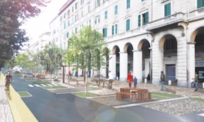
- redevelopment of building curtains along the access axis to the city from the railway station to the Archi district;
- redevelopment of the railway station road axis;
- via Marconi – entrance to the San Martino Gallery;
- enhancement of the physical relationship between the port, the first suburb, and the consolidated city.
The third main initiative for the area is the Strategic Plan “Ancona 2025”. This document is the result of the strategic plan process began in December 2014 and based on the guidelines identified by the Municipality Council. The participated process didn’t just focus on the priority of the intervention, but it has set in motion an unaware and contagious flux of action and functioning. Up from the recovery of the town-sea connection, this process gave to those who have the power to make changes a precious new point of view to act also to other areas of the city (countryside, suburbs, etc.). What came out is that in the core of the future vision of Ancona is the sea, and the many different declinations that it implies from an urban, social, economic and cultural point of view. The vision of Ancona “seaside city” is translated into three macro-strategies: Ancona Harbour City, Ancona Capital City, and Ancona City of the Mole.
These strategies are acting through five big projects in the strategic plan, between land and sea. These projects have already been started and they have a verified economic covering:
- the north boardwalk;
- the north Palombella-Archi entrance;
- the mole;
- the sea-to sea walk;
- the old port.
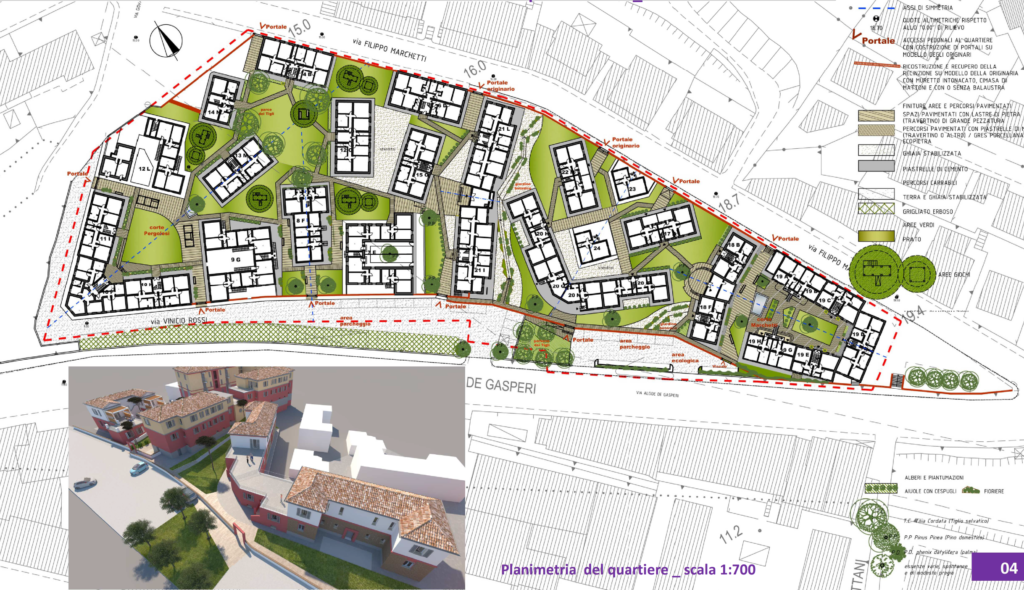
The Redevelopment program in the suburbs of Palombella – Stazione – Archi is the most significant initiative, in response to the Extraordinary program of interventions for urban redevelopment and security in the suburbs of metropolitan cities, the provincial capitals, and city of Aosta (DPCM 25.05.2016).
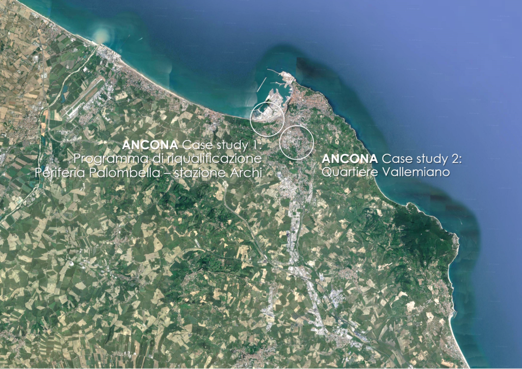
Geographical area
The area of Palombella-Stazione-Archi Suburb is characterized by a condition of marked economic and social marginalization, widespread building degradation and high hydrogeological risk factors.
Important demographic dynamics related to immigration, and consistent presence of non-EU resident population (48% of the inhabitants of the area to be redeveloped are foreigners), limited social and cultural opportunities, the presence of impressive properties in disused from the time of the great landslide of 1982 and the phenomena of contraction of the commercial and artisanal micro-industry, contribute to the characterization of the area as a peripheral context on which to intervene “for the recovery of the dignity and expressive identity of places, to strengthen social cohesion, tourist attractiveness and economic-social revival of the degraded areas”.
The project responds to the objectives of the City of Ancona’s Urban Agenda, approved in 2015 sustainable mobility; urban regeneration; new public space’s qualities; greening the city. The Redevelopment Program identifies FOUR CHALLENGES:
ch1 – To reactivate social and cultural dynamics and to reduce marginality phenomena through the timely enhancement of public real estate assets, improving overall urban quality and reducing the lack of services.
ch2 – Implement the use of forms of local public transport and sustainable forms of mobility.
ch3 – Improve the capacity for urban resilience with respect to hydrogeological risks.
ch4 – Enhancing the attractiveness and promoting the tourist, economic and social revival of the intervention area.
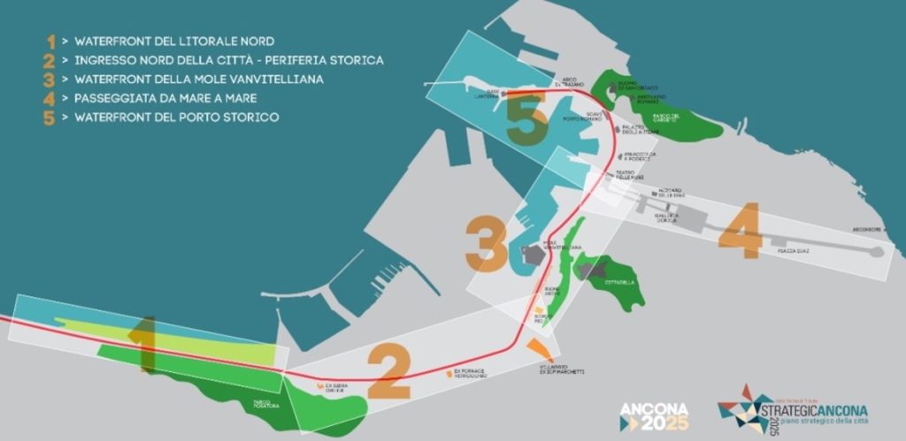
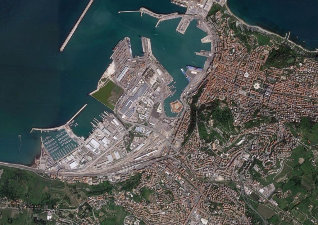
| Palombella – Stazione – Archi is a neighborhood located in the north-western part of the coastline of the city on Ancona. It represents a strategic node between the historical city and the “New Ancona”, the northern entrance to the city, and the strategic infrastructure intersection of the city for the presence of the harbor, the railway line, and the train station. In particular, the intervention area is located within the “Waterfront”, an urban system that extends from the historic port to the city center, runs along the productive and commercial spaces in the twentieth century suburbs, until thinning out at the northern entrance, coinciding with the beam infrastructural road and railway line parallel to the sea. This is the most strategic part for the development of the city, the object of the most important urban planning projects of the last decade. Inside it’s characterized by the sequence of 4 connected, but extremely diversified, urban areas: 1 – Waterfront North, characterized by the project to protect the Adriatic railway line from the meteorological action of the sea, to increase security along the way “Flaminia”, and to create a ‘smart’ park consisting of the burial of the water surface of the landslide; 2 – Waterfront Periferia Nord, characterized by the entire urban area of the neighborhood Palombella, continues to the Stazione Quartiere to the Quartier Archi. 3 – Waterfront Mole Vanvitelliana, characterized by the presence of the eighteenth-century hinge of the Mole, surrounded by the historic outskirts of the Arches and the intersection with the Porto-Passetto urban axis. 4 – Waterfront Historical Port, characterized by the presence of the Palazzo degli Anziani and the connection between the city center and the historic harbor. The area chosen for the Redevelopment Program is located within areas 2 – 3 and consists of the Palombella-Stazione-Archi Suburbs. |